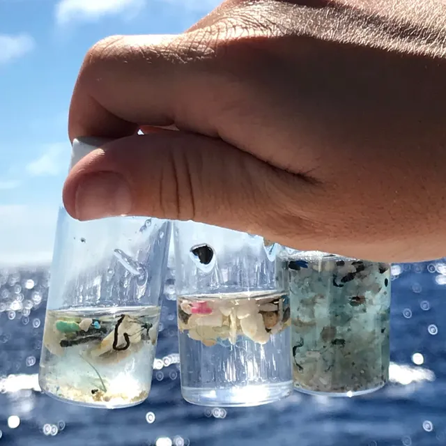
13 years after completing my Master's Degree, I'm back to doing coursework. As eXXpedition guest crew, we are expected to familiarise ourselves with the scientific framework and methods we will be applying throughout the 4-week sailing journey to and from the Antarctic peninsula. Most of the crew on the boat has a technical and natural science background, and I'm one of the few coming from the social sciences. Talk about immediate impostor syndrome...
Here are some of my course notes. Haven't done those in a while, admittedly!
By 2017, humanity had already produced 8.3 billion metric tons of plastics. About 8 million metric tons continue to be added to that every single year. Of that, only 9% has been recycled, 12% has been incinerated - and a stunning 79% ends up in the landfill and the natural environment. We have long known that a key solution to this is a circular economy - taking into account the end of life of products, and making sure we repair, reuse, remanufacture or repurpose instead of generating waste. But this is easier said than done.
Which is why the University of Georgia's Circularity Informatics Lab, who will be overseeing the science on our expedition, has created the Circularity Assessment Protocol. It provides a lens through which to understand the local waste cycle, create a standardised baseline of data, and pinpoint where action needs to be taken.
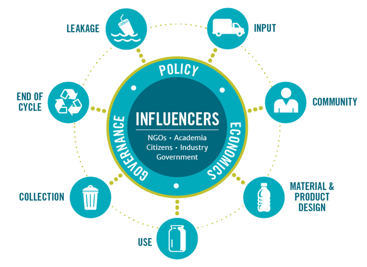
Using this overall framework, our expedition will collect data to help answer the following questions:
- What are the characteristics of microplastics in the surface water, ice and air in Antarctica?
- What are the characteristics of litter found along the coasts and land along the expedition route?
- What consumer goods are available and consumed locally, and how does the local waste management infrastructure look like?
The goal is to contribute to a global map showing how plastic moves from land into the ocean and travels around the world. The results will highlight the regions most at risk and will help to prioritise prevention, cleanup and policy interventions.
Sampling water, air and ice
Answering these questions will keep us busy on the boat. Deploying the equipment to collect surface water samples alone will take 5 people. We will need to bring a so called "manta trawl" into the water, making sure the conditions are not too turbulent and the boat is sailing at a slow and steady speed. Once we capture a sample of about 200-300ml of plastics, we will process it directly on board. That will mean running the captured plastics through three different sieves to separate different sizes of particles - from 4.75mm to 335 microns.
All while making sure we do not contaminate any of it with other microplastics, such as small threads of nylon or polyester from our clothing or sheds of rope. Apparently, there is something called the "atmospheric control method" to account for that - basically capturing any airborne particles on a filter paper next to the working area, and analysing it for any contaminants under the microscope.
I'm not yet sure how we will be able to do this with all the necessary care, while being thrown around a constantly rolling boat crossing the notoriously rough Drake Passage... And it does not stop there. After sieving the sample, we need to label, store and analyse the different sizes of particles, some with the microscope, and some with a machine called "Fourier Transform Infrared Spectroscopy (FTIR)". Sounds like a medical procedure? That's what I thought at first as well. But essentially, this is a method that uses infrared to check how much light is absorbed by a sample, and then matching this "light profile" to a database of different plastic types. Meaning, it will help us determine what polymer types we are looking at.
We will do the same thing with air samples and ice samples, after we melted the ice in (non-contaminated!) buckets. All of this will be logged and entered into data sheets, and the samples will be safely stored on board - to be taken to more quipped laboratories in the UK for further analysis.
Logging litter along the coast
For most of the expedition, we will be on the boat, but it's quite probable we have to wait for the weather to clear up to leave Ushuaia, or we might be able to stop at the South Shetland islands or even set foot on the Antarctic peninsula to visit some of the research stations. That's when we will conduct another type of data collection: so called "transect walks" on beaches, coastal areas or even further inland. These walks mean you literally walk through a random, but defined area, logging every single piece of trash you encounter - from cigarette butt to flip flop to discarded fishing net.
For this, we will use a special mobile app called Marine Debris Tracker. This has been designed in a way that anyone, scientist or not, anywhere in the world, can document and track different types of litter and plastics in a standardised way - which can then be pieced together to show a real-life picture of the amount and characteristics of trash across time and locations.
Over 10 million debris items have already been logged in the tracker, and I am pretty sure our logs will be the very first from Antarctica. All the more reason for me to take my course work seriously!
Mehr zur Forschung
13 Jahre nach meinem Masterabschluss drücke ich wieder die Schulbank. Als Teil der eXXpedition-Gastcrew wird von uns erwartet, dass wir uns mit dem wissenschaftlichen Rahmenwerk und den Methoden vertraut machen, die wir während der vierwöchigen Segelreise zur Antarktischen Halbinsel und zurück anwenden werden. Die meisten Crewmitglieder an Bord haben einen technischen oder naturwissenschaftlichen Hintergrund, und ich bin eine der wenigen aus den Sozialwissenschaften. Von wegen unmittelbares Hochstapler-Syndrom...
Hier sind einige meiner Kursnotizen. Ich muss zugeben, so etwas habe ich schon eine Weile nicht mehr gemacht!
Bis 2017 hatte die Menschheit bereits 8,3 Milliarden Tonnen Plastik produziert. Und jedes einzelne Jahr kommen etwa 8 Millionen Tonnen hinzu. Davon wurden nur 9 % recycelt, 12 % wurden verbrannt – und atemberaubende 79 % landen auf Mülldeponien und in der freien Natur. Wir wissen schon lange, dass eine Kreislaufwirtschaft eine der wichtigsten Lösungen dafür ist – also das Lebensende von Produkten mitzudenken und sicherzustellen, dass wir reparieren, wiederverwenden, wiederaufarbeiten oder umnutzen, anstatt Müll zu erzeugen. Aber das ist leichter gesagt als getan.
Aus diesem Grund hat das Circularity Informatics Lab der University of Georgia, das die Forschung auf unserer Expedition leiten wird, das Circularity Assessment Protocol entwickelt. Es bietet ein Rahmenwerk, um den lokalen Müllkreislauf zu verstehen, eine standardisierte Datengrundlage zu schaffen und genau festzulegen, wo Handlungsbedarf besteht.
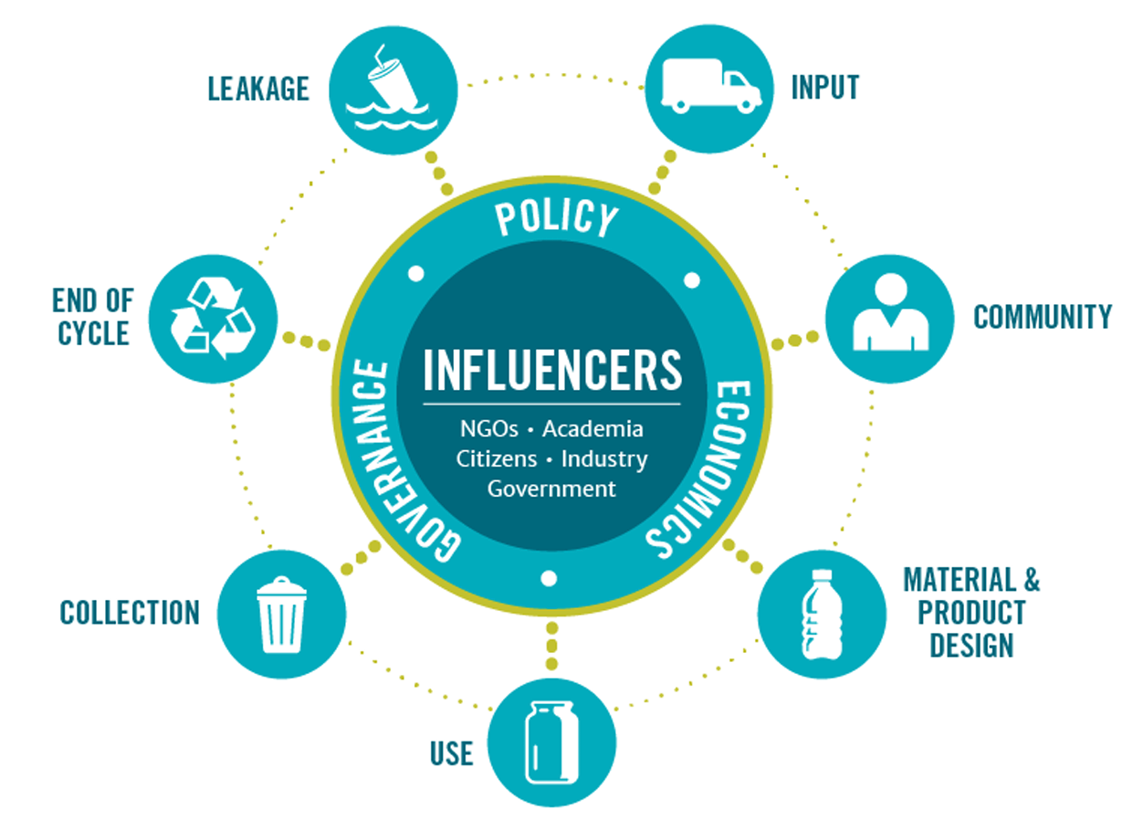
Mithilfe dieser Methode wird unsere Expedition Daten sammeln, um zur Beantwortung der folgenden Fragen beizutragen:
- Welche Eigenschaften hat Mikroplastik im Oberflächenwasser, im Eis und in der Luft der Antarktis?
- Welche Eigenschaften hat Müll, der an den Küsten und an Land entlang der Expeditionsroute gefunden wird?
- Welche Konsumgüter sind vor Ort verfügbar und werden verbraucht, und wie sieht die lokale Abfallwirtschaft und -infrastruktur aus?
Das Ziel ist es, zu einer globalen Karte beizutragen, die zeigt, wie sich Plastik von Land in den Ozean bewegt und um die Welt reist. Die Ergebnisse werden die am stärksten gefährdeten Regionen hervorheben und dabei helfen, Präventions-, Reinigungs- und politische Maßnahmen zu priorisieren.
Entnahme von Wasser-, Luft- und Eisproben
Die Beantwortung dieser Fragen wird uns an Bord auf Trab halten. Allein das Ausbringen des Materials zur Entnahme von Oberflächenwasserproben erfordert 5 Personen. Wir müssen ein sogenanntes „Manta-Schleppnetz“ (Manta Trawl) ins Wasser lassen und dabei sicherstellen, dass die Bedingungen nicht zu turbulent sind und das Boot mit langsamer, gleichmäßiger Geschwindigkeit segelt. Sobald wir eine Probe von etwa 200–300 ml Plastik erfasst haben, verarbeiten wir sie direkt an Bord. Das bedeutet, dass wir das gefangene Plastik durch drei verschiedene Siebe laufen lassen, um unterschiedliche Partikelgrößen – von 4,75 mm bis 335 Mikrometer – zu trennen.
All das geschieht, während wir peinlich genau darauf achten müssen, nichts davon mit anderem Mikroplastik zu kontaminieren, wie etwa mit kleinen Nylon- oder Polyesterfäden unserer Kleidung oder mit Abrieb von Seilen. Anscheinend gibt es dafür eine Methode namens „atmosphärische Kontrollmethode“ (Atmospheric Control Method) – im Grunde werden dabei alle in der Luft schwebenden Partikel auf einem Filterpapier neben dem Arbeitsbereich erfasst und danach unter dem Mikroskop auf Verunreinigungen analysiert.
Ich bin mir noch nicht sicher, wie wir das mit der nötigen Sorgfalt machen sollen, während wir auf einem ständig rollenden Boot durchgeschüttelt werden, das die notorisch raue Drake-Passage überquert... Und damit nicht genug. Nach dem Sieben der Proben müssen wir die verschiedenen Partikelgrößen beschriften, lagern und analysieren – einige mit dem Mikroskop und andere mit einem Gerät namens „Fourier-Transformations-Infrarotspektrometer (FTIR)“. Klingt wie ein medizinischer Eingriff? Das habe ich zuerst auch gedacht. Aber im Grunde ist dies eine Methode, die Infrarotlicht nutzt, um zu prüfen, wie viel Licht von einer Probe absorbiert wird, und dieses „Lichtprofil“ dann mit einer Datenbank verschiedener Plastikarten abgleicht. Heisst, es hilft uns zu bestimmen, mit welchen Polymertypen wir es zu tun haben.
Dasselbe machen wir mit Luftproben und Eisproben, nachdem wir das Eis in (nicht kontaminierten!) Eimern geschmolzen haben. All dies wird protokolliert und in Datenblätter eingetragen, und die Proben werden sicher an Bord gelagert – um nach der Expedition für weitere Analysen in besser ausgestattete Laboratorien in Großbritannien gebracht zu werden.
Erfassung von Müll entlang der Küste
Wir werden die meiste Zeit der Expedition auf dem Boot sein, aber es ist gut möglich, dass wir auf besseres Wetter warten müssen, um Ushuaia zu verlassen, oder dass wir bei den Südlichen Shetlandinseln halten oder sogar die Antarktische Halbinsel betreten können, um einige der Forschungsstationen zu besuchen. Dann führen wir eine weitere Art der Datenerhebung durch: sogenannte „Transekt-Gänge“ (Transect Walks) an Stränden, Küstenbereichen oder auch weiter im Landesinneren. Auf diesen Spaziergängen geht man buchstäblich durch einen zufälligen, aber definierten Bereich und protokolliert jedes einzelne Müllstück, auf das man stößt – von der Zigarettenkippe über den Flip-Flop bis hin zum ausrangierten Fischernetz.
Dafür nutzen wir eine spezielle mobile App namens Marine Debris Tracker. Diese wurde so entwickelt, dass jeder – ob Wissenschaftler oder nicht, überall auf der Welt – verschiedene Arten von Müll und Plastik standardisiert dokumentieren und nachverfolgen kann. Diese Daten können dann zusammengefügt werden, um ein reales Bild der Menge und Eigenschaften von Müll über Zeit und Orte hinweg zu zeichnen.
Über 10 Millionen Müllteile wurden bereits im Tracker protokolliert, und ich bin mir ziemlich sicher, dass unsere Einträge die allerersten aus der Antarktis sein werden. Umso mehr ein Grund für mich, meine Kursvorbereitung ernst zu nehmen!